

Data Dump: snow, guns, Bears Ears land swap
Data Dump: snow, guns, Bears Ears land swap
Plus Delta County solar denial; housing prices

It’s that time of the month—and season—again, when we check out the first-of-the-month and end-of-winter health of the Southwestern snowpack. Yes, end of winter: Although the mountains are likely to see another couple of months of winter weather, meteorological spring began on March 1, which means average temperatures are beginning to rise. And, indeed, over the last few days Denver hit 73° F, Cortez topped out at 69° F, and Moab and other low-lying areas also climbed into the sixties during the day and barely dropped below freezing at night.
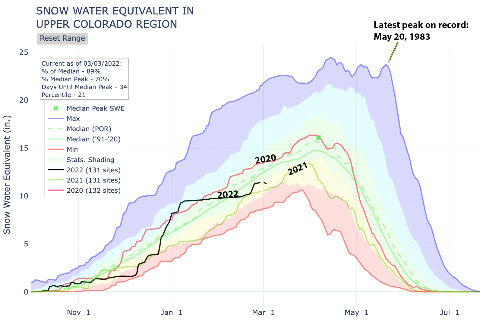
That’s great news if you want to work on your suntan after catching some spring-condition skiing. It’s not so hot for the health of the snowpack and spring runoff levels, as some of the gains from the late February storms melted away. Regardless of the season’s name or temperatures, the watersheds of the Upper Colorado River Basin are now entering what has historically been the snowiest part of the year. The median peak date for the Upper Colorado snowpack is April 6, with the latest peak (across 131 SNOTEL sites) on record falling on May 20 (during the notorious 1983 water year, when Glen Canyon Dam almost overflowed).
Glen Canyon Dam overflowing is certainly one thing we don’t have to worry about this year—or ever, I imagine. Quite the opposite:
3,526.63 feet: Lake Powell’s water surface level as of March 2, 2022.
36.63 feet Number of feet the current level is above the “minimum power pool,” or the lowest level at which hydroelectricity generation is possible.
44 feet Amount by which the lake’s level has dropped over the last year, for an average rate of 1.44 inches per day (which has accelerated to 2.4 inches per day over the last couple of weeks).
In other words, if current drawdown rates continue, Glen Canyon Dam will no longer be generating power in a year from now without modifications to the dam’s power plant. While the warm temperatures will melt some snow, bolster river flows, and increase inflow levels to Lake Powell, they have also upped the evaporation rate from the reservoir. Tune in next week for a detailed dispatch on what that will mean for the grid; for now let’s stay focused on the snow and the water it will hopefully bring.
At this point, snowpack levels are looking healthier across the basin than they did a year ago, but only barely.
The San Juan Mountain snowpack generally is more abundant than across the region as a whole, but still varies from place to place.
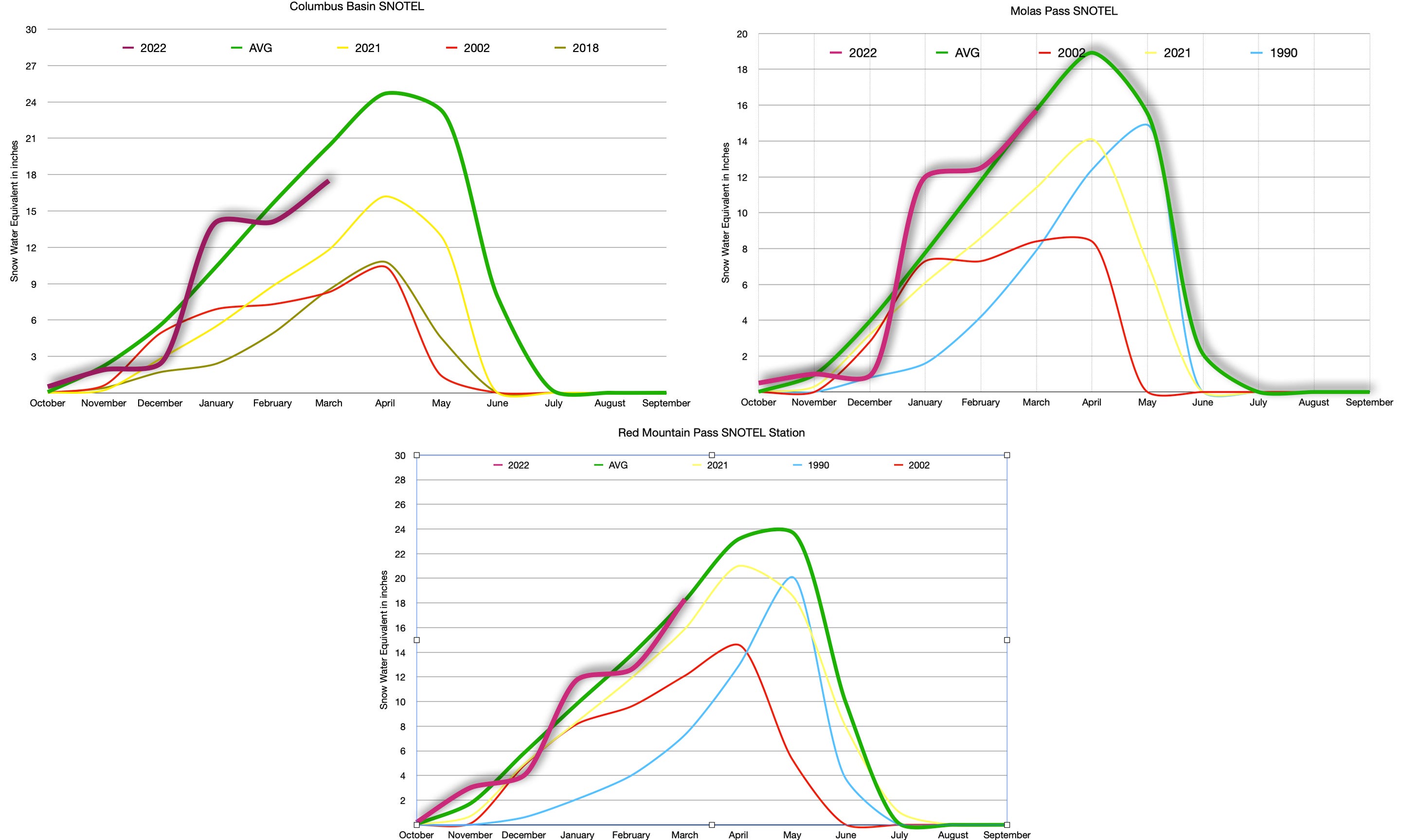
As predicted, the new snow (seen as the steep incline on the above graphs) atop the snow rotted out by the preceding freeze-thaw cycle (the flat line in January and February) set the stage for an active avalanche cycle. A slide near Marble, Colorado, caught three snowshoers and two dogs. While two of the people were able to dig themselves out, a third died, along with both dogs. And in the La Plata Mountains a Durango backcountry skier and his companion triggered an avalanche. One skier was caught in an avalanche he and a companion triggered and carried to the bottom of the chute. He suffered serious injuries, including a compound femur fracture, but his companion and rescuers were able to get him out alive.
Avalanches have killed 11 people in the U.S. so far this winter, and four in Colorado. Last winter the U.S. recorded 37 avalanche fatalities and Colorado 12.
When it comes to land-use regulations—or lack thereof—the Western U.S. has some, well, special places. But Western Colorado’s Delta County is likely to take the blue ribbon for most bizarre. Like many rural places the county takes a pro-private property-rights, laissez faire attitude towards most land uses. Wanna build an industrial-scale hog or chicken farm in a neighborhood? No problem. On one Delta County backroad someone tried to conceal their mobile-home junkyard by surrounding it with a wall—made of dilapidated mobile homes. Live and let live, right?
So you might think that a proposal to build a solar facility on 472 acres of private land would be a slam dunk. Nope. This week the Delta County Board of Commissioners voted 2-1 to deny Guzman Energy’s application to build the plant, even though the planning commission and staff had recommended approval. They cited the potential loss of agricultural land (sheep would continue to graze under the panels, according to developers) and “compatibility issues” as reasons for the rejection.
80 megawatts/194,000 megawatt hours per year: The planned generation capacity and power output of the proposed solar facility. The local electrical coop would have bought the power as part of its effort to generate more power locally.
18,000: Number of homes that could power.
$13 million: Estimated amount of property taxes the project would have generated for the county over the next 15 years, according to a statement from Guzman and DMEA, the coop.
350: Approximate number of jobs the construction phase of the project would create.
Meanwhile, over in Utah, lawmakers are trying to restrict local governments’ rights to regulate land use in their midst. A last-minute amendment to a bill relating to food trucks would prohibit towns or counties from enacting noise ordinances on off-highway vehicles, as reported by the Moab Sun News. The bill clearly targets Moab, which has tried to get a handle on the noisy vehicles which swarm town streets and area roads.
And, in more Utah political shenanigans, the Salt Lake Tribune’s Zak Podmore reports a proposed exchange of state land scattered throughout Bears Ears National Monument for more valuable federal land elsewhere is being held up by Utah lawmakers who fear the swap might hamper the states’ lawsuits challenging the national monument’s establishment.
130,000 acres: Amount of state land within Bears Ears National Monument that would be swapped for more valuable federal land elsewhere.
$80,000: Approximate revenue generated for the state from those lands last year.
$500 million: Approximate amount a similar land exchange at Grand Staircase-Escalante National Monument has netted the state.
For an in-depth look at the exchange, check out this Land Desk post from a while back:

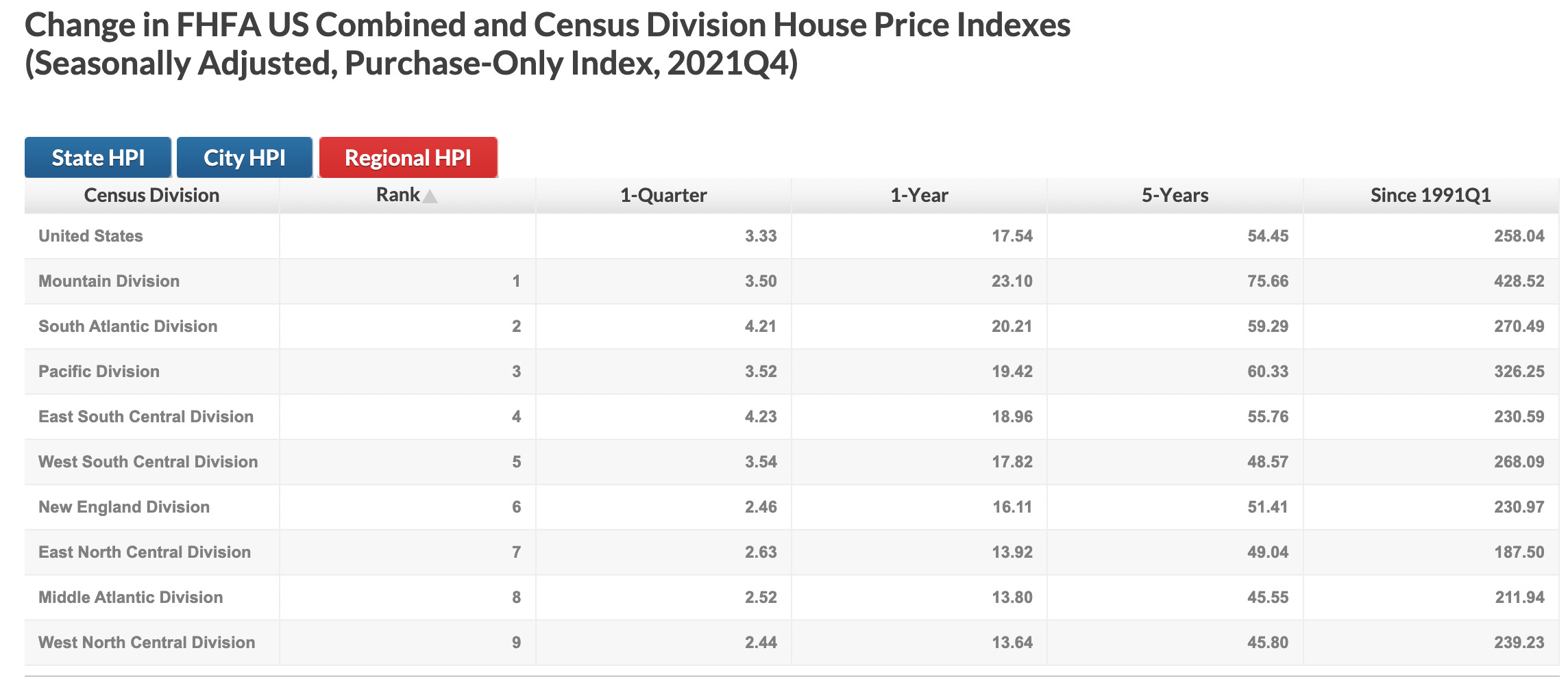
End-of-the-year statistics for 2021 keep rolling in, including these dandies from the Federal Housing Finance Agency showing how much housing costs have gone up over time. Unsurprisingly, they’ve climbed the most in the Mountain Division, also known as the Interior West, where values have shot up 23 percent in the last year, alone. Values climbed 27 percent in Idaho, Utah, and Arizona, and 29 percent in the Phoenix metro area.
Last year about this time the Land Desk reported on the unprecedented American gun-buying frenzy of 2020. The 2021 figures on firearm background checks are in, and it appears that the public’s appetite for weapons has cooled, but only slightly. Here are the figures for Western states. Note: The number of background checks conducted is proportional to the number of guns purchased, but they are not necessarily equal. In 2020, for example, the feds conducted about 40 million background checks, which represented some 20 million gun purchases. As you can see, while sales fell related to 2020, they were still higher than in any other prior year.

PARTING THOUGHT

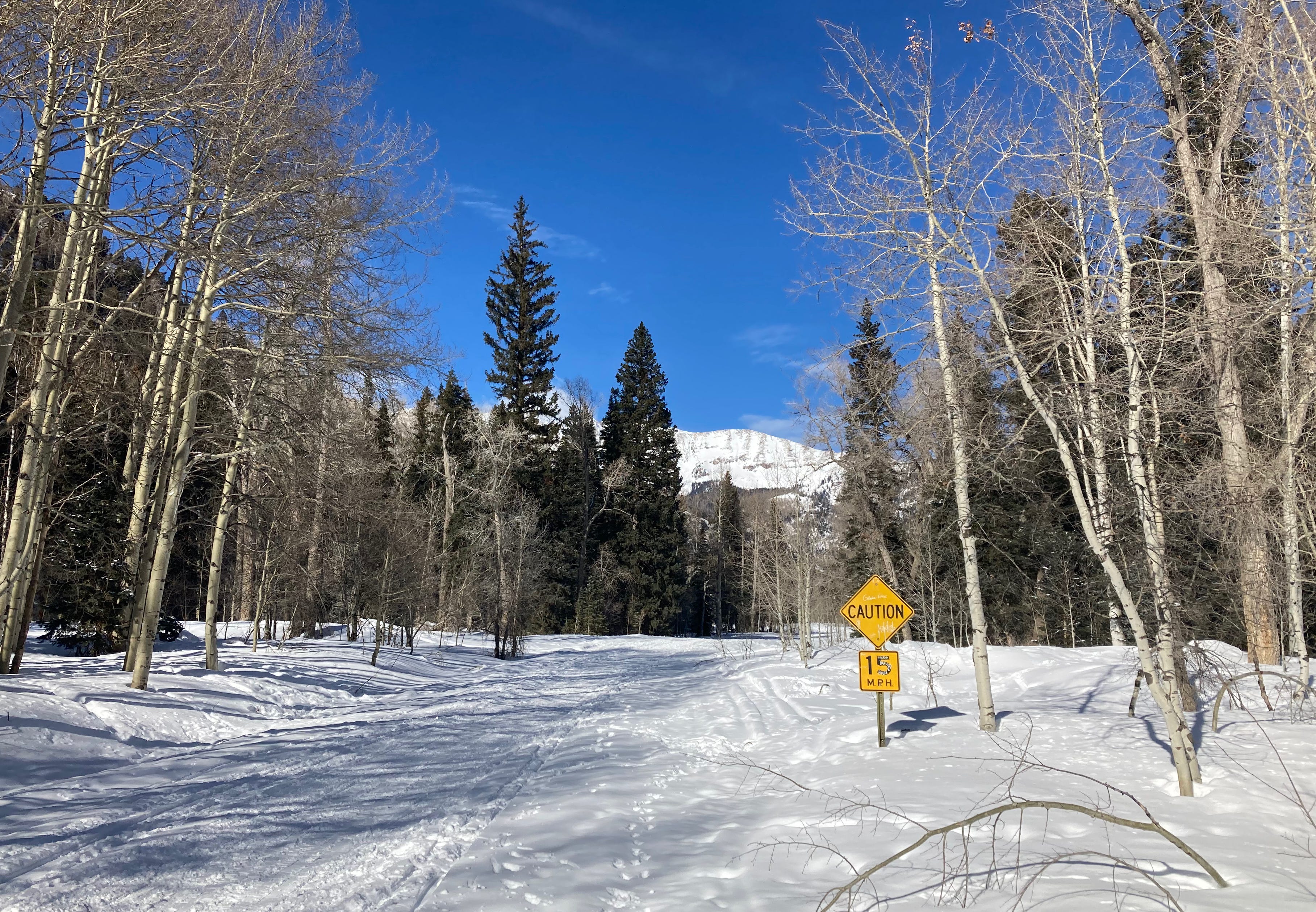
PARTING SHOT
Doesnt really give me much hope for this planet! What does it take for these little pea-sized brains to comprehend that there needs to be efforts made to save us all.
Who is the best Candidate for D3 in 2020 ?